November 2025 marks a historic moment for digital navigation in Paraguay. This month, Google officially launched the long-awaited Street View feature for the country, making Paraguay the final nation in South America to receive this immersive mapping technology.
The launch is far more than a mere technical update; it represents a significant cultural and economic milestone. For the first time, Street View connects Paraguay to the rest of the world in an unprecedentedly detailed and visual way.
Technology and coverage
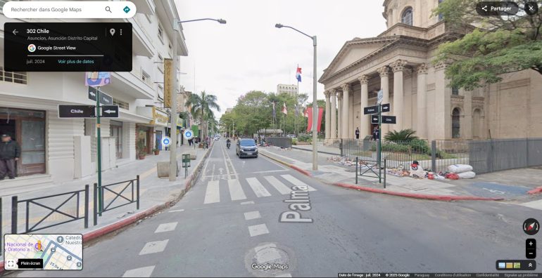
Google Street View, a core feature within Google Maps, provides users with 360-degree panoramic images at street level. This functionality transforms the user experience from simply viewing a flat map, to virtually exploring locations as if one were physically present. Whether used to explore routes, visit landmarks, or see how places have changed over time, Street View has become an essential tool for modern navigation and exploration.
Previously, only the big street of Paraguayan cities such as Asunción, Encarnación, and Ciudad del Este were shown on the platform. Now, the extensive coverage rolled out includes a majority of the country, encompassing the capital, Asunción, other major cities, principal routes, and even many rural areas across all 17 departments.
The capturing of these detailed images was a meticulous process carried out between July 2024 and March 2025. Google utilised advanced 4th Generation Trekker vans designed to navigate a variety of terrains.
Rules and regulations
The anticipation for this feature was palpable following the initial announcement months prior. The delay in bringing Street View to Paraguay was often attributed to a mix of practical and regulatory considerations. The absence of the service was primarily due to:
- Bureaucracy and permitting: Operating an extensive fleet of data-gathering vehicles across a sovereign nation requires significant governmental approval. Navigating local bureaucracy, acquiring necessary permits, and ensuring compliance with national regulations likely presented a complex and time-consuming process.
- Privacy concerns: Like many countries, Paraguay has data protection laws. Google had to adhere to strict guidelines regarding the blurring of faces and number plates to protect individual privacy, which necessitated careful negotiation with local authorities.
- Logistical challenges: The condition of certain roads and general infrastructure challenges were also cited as potential barriers to the smooth operation of Google Street View mapping efforts.
Google Street View and its future implications
Now that Google Street View is active, the potential impact is vast. For tourism, the benefits are immediate. The new technology allows potential visitors to virtually experience Paraguay’s landscapes and cityscapes. This will encourage real-world visits.
Businesses also stand to gain significantly, with improved visibility on Google Maps, enabling customers to easily locate storefronts and services. The enhancement of address data and logistical planning for delivery services is another practical application that will streamline operations nationwide.
No longer a blind spot
The integration of Paraguay into the Street View network elevates its digital presence to be on par with its neighbours and other nations globally. This update will serve as a crucial reference for urban planners, real estate professionals, students, and everyday citizens. The technology is offering a new dimension of understanding and interacting with their environment. The “Street View effect” is expected to unlock numerous opportunities, ensuring Paraguay is no longer a blank spot on the world’s most popular digital map.
With this update, you can also see most of The Asunción Times VIP partners locations!